Malaga airport transfers to Torrox
Below you can see the map with the travel route of our transfers from Aeropuerto De Málaga to Torrox. At the bottom of the map you will find the distance in kilometres in direct line to Torrox from Malaga airport and as well in road distance and furthermore all indications of how to get to Torrox by transfers and shuttle bus. You can drag the icon of the orange colored person, located in the upper left of the map to see pictures of specific points of Torrox road map and use the navigation system using the arrow keys or controls on the road map:
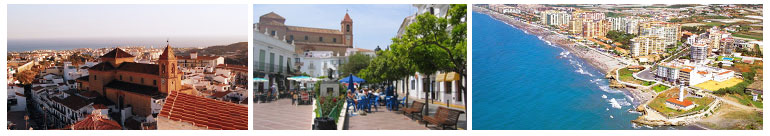
About Torrox and Torrox Costa
Torrox is a municipality in the Axarquia with two distinct parts, the inland area and the coastal zone. In the inland we find a cosy little town with several attractions such as the Plaza de la Constitucion where it is located very close the great Church of Nuestra Señora de la Encarnacion and the church of San Roque among other religious buildings. On the other hand, in Torrox Costa predominates sun and beach tourism with dark sand beaches and small coves where is situated the beautiful Torrox Lighthouse. Here you can taste typical dishes and fried fish in the bars and restaurants along the promenade.
How to get your transfer to Torrox?
Prices for transfers to Torrox if you would like to book our private transfer services.
Prices for Minibuses to Torrox if you would like to use our bus service to reach your destination.
